One of the most notable features of Svalbard is its location. It is one of the most northerly inhabited regions on the planet, located 900 km from the North Pole and almost 1000 km from the northern coast of Norway. As a result it is probably the best source of temperature data that we have for the Arctic, particularly given that there is no significant temperature data available within a radius of 800 km of the North Pole as I showed in Post 118.
That said, there are only seven stations in Svalbard that have over 480 months of data. Of these only two have over 1000 months of data with one being a long station with over 1200 months of data. The remaining five are medium stations with over 480 months of data (for a list see here). Although the Svalbard archipelago is a part of Norway, its distance from Norway implies that its climate is likely to be rather different. For that reason I am studying it separately in this post rather than with Norway (which I will examine later).

Fig. 123.1: The mean temperature change for Svalbard since 1900 relative to the 1956-1985 monthly averages. The best fit is applied to the monthly mean data from 1921 to 2000 and has a negative gradient of -0.46 ± 0.37 °C per century.
What the data that we do have for Svalbard tells us is that the change in climate since 1920 is very similar to that seen for Jan Mayen in Post 122. The climate cooled slightly until 2000 and then warmed by about 2°C (see Fig. 123.1 above). However this warming is still smaller in magnitude than the variations seen in the 5-year average of up to 4°C.
In order to quantify the changes to the climate of Svalbard the temperature anomalies for each of the seven stations with the most data were determined and averaged. This was done using the usual method as outlined in Post 47 and involved first calculating the temperature anomaly each month for each station, and then averaging those anomalies to determine the mean temperature anomaly (MTA) for the region. The anomalies were determining relative to the monthly reference temperatures (MRTs) using a set reference period, in this case from 1956 to 1985. The total number of stations included in the MTA in Fig. 123.1 each month is indicated in Fig. 123.2 below. The peak in the frequency between 1970 and 1980 suggests that the 1956-1985 interval was indeed the most appropriate to use for the MRTs.

Fig. 123.2: The number of station records included each month in the mean temperature anomaly (MTA) trend for Svalbard in Fig. 123.1.
The locations of the seven stations with the most temperature data are shown in the map in Fig. 123.3 below. Most stations are clustered around Barentsburg with two situated on the outer islands of Hopen to the southeast and Bear Island (as in the Alistair Maclean novel and film) to the south.

Fig. 123.3: The (approximate) locations of the seven longest weather station records in Svalbard. Those stations with a high warming trend between 1911 and 2010 are marked in red while those with a cooling or stable trend are marked in blue. Those denoted with squares are long stations with over 1200 months of data, while diamonds denote medium stations with more than 480 months of data.
If we next consider the change in temperature based on Berkeley Earth (BE) adjusted data we get the MTA data shown in Fig. 123.4 below. This again was determined by averaging each monthly adjusted anomaly from the seven longest stations in Svalbard. The mean temperature follows a similar trajectory to that of the unadjusted data in Fig. 123.1 with temperatures over a 10-year average (orange curve) fluctuating by over 2°C and a large peak occurring around 1930. Temperatures in 2010 are also about 0.5°C higher than in 1930.

Fig. 123.4: Temperature trends for Svalbard based on Berkeley Earth adjusted data. The best fit linear trend line (in red) is for the period 1921-2000 and has a negative gradient of -0.72 ± 0.15°C/century.
Comparing the curves in Fig. 123.4 with the published Berkeley Earth (BE) version for Svalbard and Jan Mayen in Fig. 123.5 below shows that there is good agreement between the two sets of data even though Fig. 123.5 includes data from Jan Mayen. This indicates that the simple averaging of anomalies used to generate the BE MTA in Fig. 123.4 is as effective and accurate as the more complex gridding method used by Berkeley Earth in Fig. 123.5. In which case simple averaging should be just as effective and accurate in generating the MTA using raw unadjusted data in Fig. 123.1 even though the geographical distribution of stations is far from homogeneous, as was shown in Fig. 123.3. What is truly remarkable about the graph in Fig. 123.5 below is that it suggests that Berkeley Earth thinks it can determine the mean temperatures for Svalbard and Jan Mayen as far back as 1760 even though there is no data before 1910.
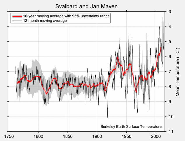
Fig. 123.5: The temperature trend for Svalbard and Jan Mayen since 1750 according to Berkeley Earth.
The similarity in the two sets of data, Fig. 123.1 and Fig. 123.4, is reflected in the scale of the adjustments made to the original data by Berkeley Earth. The magnitudes of these adjustments are shown graphically in Fig. 123.6 below. The blue curve is the difference in MTA values between adjusted (Fig. 123.4) and unadjusted data (Fig. 123.1), while the orange curve is the contribution to those adjustments arising solely from breakpoint adjustments.
In this case neither set of adjustments is particularly large. The most significant adjustment is for data after 1990 which is adjusted downwards apparently to reduce the extent of the temperature rise seen after 1990 in Fig. 123.1. The other significant adjustment is for data between 1940 and 1960. The effect of this appears to be to reduce the size of the temperature peak before 1960. Neither of these adjustments significantly affect the overall trend of the data other than to reduce the warming after 2000 to values similar to those seen in BE adjusted trends for other regions.

Fig. 123.6: The contribution of Berkeley Earth (BE) adjustments to the anomaly data in Fig. 123.4 after smoothing with a 12-month moving average. The blue curve represents the total BE adjustments including those from homogenization. The linear best fit (red line) to these adjustments for the period 1921-2000 has a slight negative gradient of -0.13 ± 0.03 °C per century. The orange curve shows the contribution just from breakpoint adjustments.
Summary
According to the raw unadjusted temperature data, the climate of Svalbard has remained fairly stable since 1930 with possibly some cooling, but may have warmed by up to 2°C since 2000 (see Fig. 123.1). Any warming since 2000 is still comparable to the natural variations in temperature seen over the previous eighty years.
Over the same period the adjusted temperature data from Berkeley Earth appears to show similar climatic variations (see Fig. 123.4) to the unadjusted (see Fig. 123.1).
Berkeley Earth has estimated the climate variations for Svalbard as far back as 1760 (see Fig. 123.5) despite there being no reliable temperature data before 1910.
The patterns seen in the temperature data for Svalbard in Fig. 123.1 (decline before 1990 and warming after) are similar to those seen previously for nearby islands of Greenland (Fig. 119.1 in Post 119), Iceland (Fig. 120.1 in Post 120), the Faroes (Fig. 121.1 in Post 121) and Jan Mayen (Fig. 122.2 in Post 122).
Acronyms
BE = Berkeley Earth.
MRT = monthly reference temperature (see Post 47).
MTA = mean temperature anomaly.
Link to list of all stations in Svalbard and their raw data files.
No comments:
Post a Comment